Part 1
 Weather manipulation - Typical scalar cloud
Earlier this year we had quite a nasty scalar-induced drought - not quite where I live on the coast of South East Queensland - but a little further inland in a normally lush, picturesque rural area known as The Mary Valley – a valley not only famous for its “Rattler” steam-train and its many elderly bridges (that tend to disappear or collapse when the water rises), but also its prolific fruit and vegetable growing and cattle raising ventures. All this happens in the valley due to the subtropical micro-climate that prevails out there, and as the locals say, “When it rains, it bloody pours out ‘ere mate”!
But the rain in the valley stopped this year, and when the locals spoke amongst themselves down at their local pub, the resounding question on everyone’s lips was…. “Geez, when’s it gonna bloody rain”?
It really was dreadful to see this normally lush valley looking so arid and parched, and I can only imagine how the local community must have been feeling, watching on hopelessly as their pastures turned dusty brown, and their fruit trees and pineapple bushes wilted in the wind and unrelenting sun – a weather ‘crisis’ they endured for many months on end with no rain in sight. By August, even those who started with full water dams and irrigation systems (for pastures and stock) were really feeling the pinch.

Although it’s highly unlikely this hard-working ‘spades-a-spade’ rural community fully understood what was happening to their normally accommodating climate, those of us who’ve studied scalar technologies knew exactly what was going on out there, the moment we looked up!
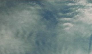
Scalar manipulated cloud over Imbil in the Mary Valley during the drought – these clouds were literally cut up and ‘herded’ away from the area. There’ll be no rain here today!
Photo taken late morning 28th August 2006.
By August this year, the residents of the Mary Valley were almost at the end of their tether with the drought, and during a visit to an Imbil property on the 28th (the day we took the above photo), the people we bumped into were at the point of ‘willing’ it to rain. “Even a mil would help” they said.
Earlier in the morning of that day (the 28th) we’d heard a weather forecast that indicated the strong likelihood of rain for the Mary Valley that day. It was while we were waiting with hope and expectation for the rain to arrive, we witnessed – and not for the first time - scalar interferometers at work in the Imbil sky. On two other occasions we’d seen similar patterns ‘start forming’ (indicating artificial manipulation) in the clouds above Imbil, and on this particular day the stuck around into the early evening, effectively preventing the BOM’s (Bureau of Meteorology) predicted precipitation over the Mary Valley. On one of those previous occasions when we had witnessed scalar activity (mid-week late July) we’d also seen a series of chemtrails being laid by a high-altitude aircraft – so high in fact we couldn’t actually see the craft itself, just the trails it was leaving behind it. They were NOT normal contrails, and there were enough of these rogue trails in evidence for us to acknowledge that this area of the sky was being thoroughly ‘worked over’.
PLEASE NOTE: If you are new to the subject of scalar weather manipulation and covert aerial chemical spraying, please refer to the links in the references at the bottom of part 1
Anyway, back to the scalar ‘attack’ on the 28th August - We spoke by telephone to my daughter back on the coast, and asked her to check the BOM Internet site to see if there was any sign of the predicted rain coming our way. She reported back to us a little later “yes”, she was tracking moderate to heavy rain steadily making its way straight towards us as it headed in a North-Westerly direction up the inland coastal area. By her estimates it looked as though it would reach us within the hour. Indeed, within the next half hour from a high vantage point, we could see the rain approaching from the south, but as we watched in dismay, it seemed clear to us the rain that was meant to fall on the valley, was in fact being ‘mysteriously’ diverted away from us. At this stage, there was still tell-tale scalar “cuts” in the moderate cloud present above us, and as more time passed, from where we stood watching, some of the rain cloud to the east of us had traveled northward dropping rain to the north of us, and some cloud had been diverted round us and was heading inland and providing rain for those areas. Not one drop fell in the Mary Valley that day!
By now we were getting quite angry. As you can imagine, when rain is so badly needed, the frustration of watching it fall in the surrounding areas (where rain has not been lacking), was enormous!
By 6pm that evening, it seemed quite obvious the valley was being prevented from getting any rain at all, so I again phoned my daughter and asked her to go back on to the BOM site and take a screen-capture of what was visible on the radar loop at that time – something I should have asked her to do earlier. However, the evidence of interference was clearly still present on radar, and below is one of those captures - even to those unfamiliar with scalar weather control, it should be obvious something is very wrong here.
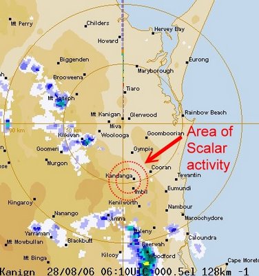
Screen capture taken from the BOM site at 6.10pm August 28th where you can quite clearly see how the rain that should be falling on the drought stricken Mary Valley is being deliberately steered inland and away from where it was needed the most
But as bad as this lack of rain was to the good folk on the land in ‘The Mary’, something even more disturbing was keeping many of them awake at night - Something more devastating for the people, the wildlife and the land.
References for Part 1.
 The Weather Wars website is by far the best ‘first port of call’ for those who wish to learn
about weather manipulation. Please take your time and have a good look
round this site, and don’t forget to check out the archives section.
http://www.weatherwars.info
 Colonel Tom Bearden’s comprehensive website is worth a visit.
This link will take you directly to his pages on weather weapons.
http://www.cheniere.org/index2.html
 Gaiaguys have a lot of information on weather manipulation, particularly in regional Australia.
http://www.gaiaguys.net/Chemtrails.htm
For further information Google “chemtrails” and “chemtrails over Australia”.
Please go to part 2 link in the right-hand side bar.
posted by Lime @ 8:11 PM
1 comments
![]()


1 Comments:
That is just the start of the Rabbit hole.
Post a Comment
<< Home